Saturday, August 4, 2007

Sequoia/King's Canyon Backpacking-with Emergency

Part of the challenge and the appeal of backpacking is being ready for the unexpected. As backpackers, we chose equipment for the conditions we’re likely to encounter, build in a safety margin, and accept the responsibility remote terrain demands. As skill levels increase the safety margin can be provided more by knowledge and less by weighty gear. Planning a trip requires an honest evaluation of your own skill level and that of your group. What is your fitness? Who isn’t comfortable with class III cross country? Does someone have a medical condition that may influence their abilities? Can you pick a safe route through rough terrain and will you backtrack to avoid scrambling that is over your head? A leader needs to continually reassess his group on a trip. Who didn’t sleep well and can’t hike 20 miles today? Whose “bum knee” is acting up? You need to know your route, have contingencies to cut a trip short, and know what emergency services are available at any trailhead to which you might evacuate. You should consider your route in relationship to weather, seasonal snow pack, and elevation. Can you expect to go cross country at 7500’ when you know man eating manzanita grows on south slopes at this elevation? Will you be able to cross a river in the afternoon on the third week of July when the watershed is still full of snow? The longer and more remote the trip, the more detailed the planning should be.

This is the story of a serious illness in a remote part of the Sierra Nevada. It has a happy ending largely because of advanced planning, the group’s level of fitness, experience, and lightweight ethic. In retrospect, there may have been other steps that could have improved the outcome further. It gives an example of a commitment to self rescue and the decisions that led to this possibility.

It started out well enough. Four excited people out for an 80 mile, four day trip in King’s Canyon. All of us had prior backpacking experience and were in good shape from running ultramarathons. Lee, who sells medical equipment, was in peak shape for a 100 mile race a few weeks later and had been on several backpack trips earlier in the season. Jeff, busy putting together computer network deals, hadn’t been running as much and was on his first backpack trip in several years. Jackie, Jeff’s wife, also hadn’t backpacked in years, but had been running and hiking with a pack to get ready. They had arranged grandparent babysitting so they could enjoy the trip together. As the leader, I’ve spent more than 1000 nights on backpack trips. One month earlier I had run the 223 mile John Muir Trail in just under four days and was looking for a tough trip but one where I’d actually get to enjoy the mountains. I’m comfortable with long trail days, unroped class IV cross country, solo backpacking, and navigation. As a physician I’m familiar with the medical conditions unique to high elevation travel. I carry a 6oz “prescription strength” first aid kit to match.

Our loop was to include dramatic high mountain cross country on the first northerly miles of the unofficial “Timberline Route”. It would join and head south on the John Muir Trail with a final night’s camp at Rae Lakes. On the final day we would cross Glen Pass and return to King’s Canyon down Bubb’s Creek. I was especially looking forward to the Rae Lakes camp. When I ran through Rae Lakes a month earlier I enjoyed brief glimpses of evening colors on the steep headwall called the “Painted Lady” and could sense the tranquil, moist, still, and cool evening air. But I had to run on into the darkness of Wood’s Creek and missed being part of that stillness and beauty. On this trip I promised to fully surrender to the evening I had missed at Rae Lakes. It was a promise which I would not be able to keep.

We began a little later than planned at Cedar Grove and began the 11 mile, 6000’ climb to Kennedy Pass. A slightly slower than expected pace and late start had us arrive at Kennedy Pass two hours later than planned. Because of the delay and reports that Pine ridge trail was blocked with multiple fire downed trees we elected to go cross country to Granite Pass via Volcanic Lakes. The class II/III scrambling slowed us again and it was just before dusk when we crossed the trail at Granite Pass and camped at Lake 10,785. Everyone was tired but in good spirits.

The second day started by breaking camp quickly and hiking 1 ½ hours. We had breakfast and coffee at the view-rich tarn atop Glacier Pass. By late morning crossing the State Lakes valley, Jeff was feeling more worn out than he should and his fingers were swelling. He didn’t feel especially short of breath or have a headache and his appetite was good. He told me of a prior elevation problem, and he declined using Diamox. We continued a good pace despite a long lunch and swim at Horseshoe Lakes. Our crossing of White Pass was slowed when we crossed the ridge 600’ too high and descend a steep talus/scree gully. We carefully descended two by two (on opposite sides of the gully) to a small fork of Cartridge Creek. As we ascended toward Grey Pass Jeff really began to lag. Despite our intention to cross Grey and Red Passes and camp at Marion Lake (10,300’) we stopped short at 11,200’ in a lovely meadowed bowl complete with trickling stream, glacial polished granite kitchen, and sandy tent sites.

By the third morning it was clear that Jeff was really sick. He hadn’t slept the night before due to feeling he had the flu and an upset stomach. He felt dizzy, was unable to concentrate, and had a haggard look. He was lagging well behind the group and reported feeling short of breath. His lungs sounded clear when I pressed my ear against his back on top of Grey Pass and he answered coherently. His feet and fingers were swollen. We forced coffee and oatmeal on him at Marion Lake, but even a long rest didn’t restore him. He took a small dose of Diamox at Marion Lake but continued to feel miserable. It was on the way up Cartridge Creek, that his pace dropped and he had to stop and rest to catch his breath every 2-3 minutes. I made a diagnosis of acute mountain sickness with possible early pulmonary edema. We were now about as far away from a trailhead as we could be. It was time to carefully consider our options and try to get out on our own.

High altitude illness is better avoided than treated. Slow elevation gain—typically less than 2000’ per day once over 8000’—can help prevent the problem. Once an altitude illness develops, the best treatment is descent to lower elevation. Even as little as 2000’ of descent can improve symptoms significantly. Medications can help prevent and treat these illnesses, but generally aren’t available as a prescription is required. Although I did have Diamox available, Jeff hadn’t wanted it the second day when he first became sick. He was now vomiting and so couldn’t absorb any we gave him. This made descent our only realistic option. The most immediate way to lose elevation would be to descend Cartridge Creek to the Middle Fork of the King’s River and exit at Wishon Reservoir. This would get us low quickly, but make us dependant on getting a ride back to our cars and to the hospital if Jeff’s condition didn’t improve. It was also a 40 mile trip. A shorter option was to cross Cartridge Pass, descend into the South Fork of the King’s River, cross Taboose Pass and drop to Highway 395 on the east side of the Sierras. For this option we would need to climb two 12,000’ passes and would again be dependant on getting a 250 mile ride back to our cars from a no telephone trailhead. Pre-trip planning had a Wood’s Creek exit as an option to shorten the trip, but this again would involve crossing two 12,000’ passes and significant mileage. The final option was to cross Cartridge Pass (12,000’ but now only 2 miles away) and continue down the South Fork of the King’s. This would give us one high pass but would let us drop quickly and permanently below 9000’ and get us back to our own cars. The main disadvantage was the lack of a trail down the canyon. Looking at the topographic map I could envision the giant talus and overgrowth likely to be present in a narrow 3000’ deep canyon. There was a risk taking a sick person down this route but it was the shortest option, would get us permanently to low elevation and back to our cars. We decided it was our best option.

As the three of us divided up the contents of Jeff’s pack we were glad we were traveling light!! With heavier packs, it would have been much harder to help him as much. I assigned Lee to “pace” Jeff as I noticed that Jackie was more sympathetic towards Jeff and was less likely to encourage forward progress and regular intake of food and fluid. Jeff vomited several times while crossing Cartridge Pass, but remained coherent and able to hike slowly. He did not report a headache but just wanted to sleep. Once over Cartridge Pass we reassigned Jackie to take care of Jeff’s while Lee and I descended to Lake 10,860 to have soup ready for Jeff to eat when he arrived.

Jeff ate little at our lunch stop and slept for two hours. He felt little better as we continued to descend to the South Fork of the King’s. When we arrived we left the trail and initially followed easy cross country through the pine forest duff. Then the canyon narrowed and we began to climb over car to cabin size talus and wade through dense Aspen and Willow saplings. We scheduled a 5 minute rest for every 20 minutes of hiking and encouraged Jeff to eat. However jelly-beans were all he could keep down. When Jeff reported feeling dizzy and unable to concentrate and began stumbling in the dense undergrowth, I became concerned that it might not be safe for him to continue. In full view of the narrowing canyon we came to a wide granite shelf I felt might be the last place that would allow a helicopter landing. I laid out the options to Jeff in certain terms: keep hiking or stop here and let Lee and me hike out and call in a helicopter. Jeff was unwilling to surrender and drew on his experience pushing through misery as an ultrarunner. He rallied for an additional two miles for a late camp at 8800’ and dinner in the dark. He was able to help set up camp and even kept down a small part of dinner.

Overnight the low camp elevation effected its treatment. Jeff, while not back to normal, showed his bravado by yelling us out of bed at 6am. He was able to eat a decent breakfast and keep up the jocular banter characteristic of our trips first days. With less worry about Jeff, the amazing beauty of the canyon became apparent. It was a snaking granite causeway never more than ¼ mile wide with 4000’ vertical to the peaks high on both sides. The walls were sculpted in turrets and spires with talus fields littering the bottom as an afterthought. The riverbed usually allowed for the fastest progress and was replete with small falls and pools. This would have been a much more difficult trip if it hadn’t been September in a low snow year. A dipper served as our guide down nearly ½ mile of the canyon and several small falls cascaded from the cliffs above. It more than made up for the missed night at Glen Lakes.

As the day progressed and our elevation continued to decline, Jeff returned fully to normal. We arrived at the cars, bathed quickly, and began the long drive home. As memories bubbled up in the introspective time after a long trip, many questions surfaced. Had we ascended too quickly? We camped at 6400’ the night before the trip then at 10,800’ the first night out and 11,200’ the second night. I’ve certainly followed this pattern before without any problems. Planning for a slower ascent or lower campsites may have been safer. Should I have screened the group better? I screen my Sierra Club group members before accepting them on trips, but didn’t do this for someone I knew well. Jeff had actually had bad headaches at elevation before which I didn’t know about. Was there anything else I could have done once Jeff got sick? Here I feel that I should have advised Jeff to start Diamox earlier and continue it even when he got really sick. It might have kept the problem from getting worse or helped it resolve sooner. Should I have chosen a different way out? Certainly if Jeff had been sicker, descending Cartridge Creek would have been a better option. Here the best immediate medical response for an individual would have made the group overdue at least a day and necessitated begging for a 100 mile ride. It was more risky to go cross country, away from other hikers that could have helped and into a rough trail-less area but it was the only option that preserved a self rescue.

Mountains are unconcerned with the processes of man. Every step and every storm gives us immediate and impartial feedback on the consequences of our actions. The simple and pure experience can not but result in faith that the actions of our everyday life also make sense and have meaning. Time spent in the mountains represents a smaller portion of life but the clarity an attentive visit can provide casts a reassuring light on the larger but fragmented life we otherwise live. We must approach the mountains fully responsible for ourselves and fully accepting of the consequences of our actions. If we succeed we grow and become part of their slow and permanent glory. If we fail we retreat into a smaller portion of a more diffuse life.

First Aid: Ultralight Style

The rule “if you don’t use it take it out of your pack” just doesn’t apply to first aid kits. How do you design a light first aid kit without compromising safety? Start by sizing your kit for your group and trip length. No need to take eight days of a medication if you’re only going to be out for a weekend. Make sure only one person takes the “industrial strength” kit so the weight isn’t duplicated. However everyone should have the basics or they’re less likely to use them early when they can do the most good. An individual should also bring any specific medications they need such as an Epi-pen if they’ve experienced severe sting/food allergies. Don’t forget personal prescriptions. Next consider the specifics of your trip. If you’re not going above 8000’ you probably won’t need altitude sickness medications. Plan your kit for the common problems you’ll encounter. Blisters rank among the most common and can become dangerous if infected. It’s important to take a good variety of dressings and tapes to treat them. Sprains and cuts are also common. A small array of bandages (including steri-strips) are important. Finally know how you can improvise and what “non-medical” treatments work (like descent for the altitude illnesses) so you don’t have to carry everything you might remotely need. Splints can be made with sticks, rope, and torn clothing. Ripped cloth can be used as gauze for large wounds if first sterilized by boiling or soaking in a dilute iodine, bleach, or Aqua Mira solution. Large volumes of water rinse wounds and a dilute water purification solution can replace a specific disinfectant.

Altitude Illnesses:

Acute Mountain Sickness—Headache, nausea, vomiting, weakness, malaise, poor sleep. Usually occurs 24-48 hours after a too rapid ascent. Worsened by exertion, best treated by dropping 2000’ and ascending more slowly. Can use Diamox 125mg twice daily for 5 days prior if prone, 250mg twice daily once it develops.

High Altitude Pulmonary Edema—Shortness of breath often with audible rales (crackling sound like crumpling paper), blue color (in severe cases) best treated by RAPID descent. This is an emergency!! Can use Nifedipine if available.

High Altitude Cerebral Edema—Headache, confusion, hallucinations, incoordination best treated by !RAPID! descent. This is an even more severe emergency. Can also use Decadron if available.


High Altitude Flatus—The tendency for passing increased bowel gas at high elevation is generally not a serious medical problem except in markedly anal retentive ultralighters. Tentmates may become short of breath and turn blue in more severe cases. Tarps minimize this effect and are recommended as a preventative.

First Aid Kit: My 6.2 oz of protection

Wound closure

4 circular/4 standard cloth type “Band-Aids”

2 small/2medium Compeed patches

2 packages of Steri-strips

Blister Tape—Leukotape P sports tape or Kinesio waterproof (Sticks better than Duct tape and breathes)

Small roll of sports tape

2 safety pins

small bottle of benzoin

Medications (Rx=need prescription*)

10 Aleve (12 hour duration anti-inflammatory)

10 Benedryl—sleep aid, allergic reaction

6 Tums—indigestion, reflux

6 Imodium—diarrhea

4 Vicodin (Rx)—severe pain

6 Diamox 250mg (Rx)—altitude illness

6 Doxycycline 500mg (Rx)—broad spectrum antibiotic

4 Hydroxyzine (Rx)—sedative/pain

4 Decadron (Rx)—allergic reaction, altitude sickness

2 small foil pouch topical antibiotic

*Your personal physicians may be willing to prescribe small quantities of many of these medications for trip use. Make sure you know how to use them before you go. Write down directions and seal them in a waterproof bag. Keep track of expiration dates. If you’re not sure of what you are treating, DON’T.

Miscellaneous

25 Iodine pills—antiseptic, emergency water purification

Water/windproof matches, firestarter

2 needles in small insulate piece, wrapped with 10 years heavy thread

mini-photon light with locking on switch on elastic wrist strap

Other—stored elsewhere

Tweezers/scissors/knife on smallest Swiss army knife

Everything is stored in a waterproof ziplock bag(s) for easy visualization/access. Keep iodine away from anything metal—best to store with bandages.

High Sierra Route Record, August 2005


Sierra High Route

The Timberline or Sierra High Route is a 195 mile route scouted by Steve Roper and described in his book Timberline Country. It roughly parallels the John Muir Trail, but in contrast largely remains above timberline and consists of about half cross country travel. It has 60,000’ of elevation gain, nearly 50% more than the similar length John Muir Trail. It crosses 32 passes all but three of which are un-marred by a trail. To hike it requires the ability to negotiate class II/III cross country and absolute confidence in navigation and route finding. Steve Roper’s book divides it into five sections and suggests that each section would be best tackled over a week. I was looking for a little tougher challenge and have set aside nine days. Not that I wanted it to be miserable: I wanted a trip tough enough to challenge my physical prowess but easy enough to enjoy. I wanted intensity and a small portion of desperation but I also wanted time for celebration and quiet respect. I wanted to walk a line between full exertion, full alertness, and full exhaustion. In short, I wanted to be fully alive. When it was done I wanted to bring some measure of this type of living back to my everyday life.

With every “project” backpack trip I like to understand the experience I’m looking for before I leave. Before I left for the John Muir Trail in 2004 I was committed at all costs to speed. I wanted to set the record and knew there would be misery involved and no time to stop and enjoy. That’s not what I’m looking for on this trip. I want a trip that will be physically demanding but I want more than a pure physical challenge. I want time to contemplate the more spiritual elements of the alpine zone.

Why do I backpack? It’s to experience a way of living generally unavailable today. Our lives are so cooperative and specialized it’s hard to see the results of your actions and decisions. In days gone by it seems that people were more directly affected by their day to day actions. If they planted and the weather cooperated, they ate. If they cut wood and kept it dry, they stayed warm through the winter. Backpacking lets me see the results of my decisions and preparation. Every decision before and during the trip has consequences that reverberate throughout the trip. Every step can bring you closer to your goal or result in a twisted ankle. The feedback is immediate. Lightweight travel amplifies the importance of each decision and places a premium on things you can’t carry in a pack: experience, imporvisation, and knowledge.

Friday August 19, 2005 2pm

My GoLite Speed pack modified for lighter weight sat by my door. Inside was a home made tarp and bivy sack, a 13 oz Nunatak sleeping bag, and assorted personal items. Carbon fiber hiking poles and a matching bear canister filled with 6 days of food sat beside my pack. A pair of Montrail Hurricane Ridge runners sat on my bear canister. I had carefully chosen my gear for the conditions I was likely to encounter and kept the base weight to 7 pounds. With the required 2 pound bear canister, 6 days of food, and 4 pounds of water I would start hiking with a 25 pound pack.

Saturday, August 20, 2005

I woke at 5:50am with the first light and left our bandit camp by Mammoth at 6:30am after breakfast. Dad drove me to the Taboose Pass trailhead and I started hiking at 8:35am. While the route “officially” starts at Cedar Grove I started at Taboose because of transportation. It’s a long drive to either trailhead, but my father, sister, brother-in-law, and niece had a backpack trip planned on the eastern Sierra and could drive me to Taboose Pass. This shortened the trip by about 6 miles and 3000’ gross elevation gain. I would have liked to do the whole route, but I didn’t feel too cheated. I led a trip the previous summer from Cedar Grove along Steve Roper’s “official” route to where I intersected it in the upper Cartridge Basin on this trip.

It was already 91F when I left the trailhead and there was no breeze chattering the branches of the desert scrub or cooling me. The trail sits in a desert filled with sage, sand, and lava. Taboose Creek gives a curving line of more varied and verdant life as it spills onto the desert. Then it’s sucked up by the Los Angeles/Owen’s Valley water project and the extra life provided by the creek is gone. The trail went up in fits and starts like an old rollercoaster and I was excited wondering what the ride would be like. The canyon walls were steep, and fresh crushed aspen and pine gave evidence for the power of the season’s avalanches.

A solitary juniper appeared and introduced me to his neighbor a Jeffrey Pine. A small grove of red fir appeared adding their sweet and pungent smell. A single leaf pinion faded into the distance as I climbed. Finally I moved from the heat of the south facing slope to the cooler shade of the north exposure and its’ red fir forest. Huge ramparts of granite appeared to block the way, but the trail dodged right following the creek as it sliced between the steep walls. As I rounded the corner, a steep 200’ cascade appeared and the smell of willows was in the air which had cooled to 75F by the breeze. After only two hours I already had a painful heel blister. It was still a very long way to Twin Lakes.

As I continued to gain elevation, the trees showed evidence of the many tough winters they’ve faced. Many of the trees had been bent by the snow or topped by an avalanche. Their branches were thin and many on the windward side were dead. I share an empathy with the struggles of high alpine trees. Sometimes when I’m having a tough day I pause and my mind pulls up the image of a specific tree at a specific place, adds snow, an icy wind, and imagines the toughness required just to survive. This resolute image strengthens my determination and makes my difficulties disappear.

I continued to climb past small streamside willow, purple heather, and the occasional grassy meadow. Up I continued past where roots can grasp hold of a meager living but a full life. Here life is simpler, containing only rock, air, and snow. Soon the raucous call of a Clark’s Nutcracker welcomed me to the top of Taboose Pass.

The trail from Taboose Pass to Cartridge Pass follows the early route of the John Muir Trail before Mather Pass was carved into the granite ridge separating the South and Middle Forks of the Kings River. It was abandoned many years ago and is so over grown that I chose a cross country route across a steep talus field. This route turned out to be more difficult than what I was trying to avoid. I stopped by a small side stream 800’ above the Fork of the Kings for a drink and snack. The view was so expansive I couldn’t capture it in a picture. I sat on a sheet of granite with a stream cascading by. Across the canyon I could see the Bench Lake plateau and Mts. Ickes and Pinchot. The stream was surrounded by small willows, grass, and a riotous assortment of purple lupine, purple and white mint flowers, yellow marigolds, and blue asters. A golden eagle soared by just below eye level. Only the gush of the stream and a distant wind broke the silence.

My day became tougher from here. My late starting time means my planned 12 hour day will end at 8:30—in the dark. In the Lakes Basin I almost stopped at 6:30pm on a sheltered wooded ledge. However, feelings of loneliness drove me on over Frozen Lake Pass. My campsite just south of Mather Pass was very close to where my wife Carol and I stayed over 10 years ago. While the day started as a balanced day it turned into an athletic push. I hoped tomorrow would be easier. I wished for more company than the babbling stream and the full moon.

Sunday, August 21, 2005

The meadows of the upper Mather Basin were covered with frost in the morning. The moon had just crossed Frozen Lakes Pass for its day of sleep when I awoke and I started hiking just as the sun hit the tip of Vennacher Needle. The south side of Mather Pass was in the sun, but after crossing the pass I was in cold morning shade nearly all the way to Palisade Lakes. What a valley! The lakes are filled from numerous small streams that pour in from all sides. There are small stands of whitebark pine and so many flowers it felt like spring despite my late summer date. The few mosquitoes were mostly blown away by a light breeze. After six miles on the John Muir Trail it was time for cross country travel again. I ascended the steep but technically easy climb up Cirque Pass where shooting stars decorated the meadows. Small cascades gushed exuberantly over rocks and through their crevices. It took 40 minutes to cross to Potluck Pass where the view of the Palisade Group was nothing but grand. Their solid grey spires slashed with random stripes of white rock and snow were a cause for celebration.

Crossing from Potluck to Knapsack Pass involved picking routes through multiple short cliff bands that were invisible until I was on top of them. I often had to backtrack 100’ to go forward 200’. My route was interrupted by a lakeside cliff on the south shore of Barrett Lake but I decided to wade across instead of climbing around. Water always looks shallower than it is. My wade was waist deep and my log book and a topo map got wet before I had finished crossing. The five hours it took to get from Palisade Lake to the Bishop Pass Trail began to feel like unpleasant work. The descent into LeConte Canyon took a hot hour but minor thunderheads helped cool the ascent of Muir Pass through this glacially carved canyon. There were stands of hemlock, whitebark, and lodgepole each with their distinct aroma. I predicted a late crossing of Muir Pass and was proved correct at 7:20pm when I arrived. The last of the day’s sun faded from the Muir Hut as I descend to the outlet of Wanda Lake for the night. I hoped for an easier tomorrow as I cooked dinner by headlamp.

Monday, August 22, 2005

It was perfectly still across Wanda Lake when I got up and the reflections of Mts. Huxley and Warlow were hard to distinguish from their originals. The descent to Evolution Lake was an adventure in gentle meadows surrounded by the most rugged and desolate mountains of granite with chiseled rubble from their formation still filling the canyons at their feet. It was cold with only the promise of warmth as the sun lit the tips of these stone statues. I had breakfast overlooking the glacially carved Evolution Canyon. Glaciers, despite their power to shape, were turned by more solid rock several times as they descended this canyon.

I continued across the relatively level ledges of the Darwin Bench and descended into the first of its lakes. Copse after copse of welcoming whitebark pine greeted me on the way. As I sat by the small lake, the distant caw of a Clark’s Nutcracker and the close up chirps of Juncos complemented the streams’ quiet gurgle as it strained through numerous dark boulders. A curious Junco fluttered just behind me and scolded me for being too close to her nest. It was warm, still, and intimate.

So carefree was my mood that I just about missed Snow Tongue Pass and descended into Paine and Packsaddle Lakes before looking more carefully at the map and realizing that the lake below couldn’t possibly be any of the Wahoo Lakes. I turned on my GPS which informed me I was ¼ mile away: at least if I could fly. The descent to the real Wahoo Lakes wasn’t as bad as advertised as I enjoy hopping along the top of car sized boulders.

From a distance all wilderness looks forbidding. Looking across Humphrey’s Basin, barren rock and scraggly trees is all that is apparent. However when you get closer, a myriad of comfortable and inviting features beckon. My lunch meadow perched above Wahoo Lakes was one of these small paradises. It was a small meadow with a view of Wahoo Lakes, a trickling stream with a dry grassy edge, and a sloped and smooth granite boulder to lean against.

French Canyon was full of mosquitoes and I delayed my afternoon snack until Marion Lake to avoid them. I continued on to the top of Feather Pass at 6:50pm. Feather Pass derives its name from Feather Peak which has such abrupt thin flakes of granite they look like feathers stuck in the ridge. On the descent I broke a pole over a square granite boulder when it plunged deep in the snow and I lost my balance. The soft snow allowed rapid travel and I arrived at Bearpaw Lake only 30 minutes later for my earliest camp. I celebrated with freeze dried blueberries and a hot cup of tea. No moon was out as I went to bed and the Milky Way dominated the sky as it never can in the city.

Tuesday, August 23, 2005

I started again at 6:30am and hiked over White Bear Pass after greeting a group of four climbers on a bench above Black Bear Lake. I was so focused on the route down to Brown Bear Lake that I forgot to leave my standard marker on the pass. On every pass and trail crossing of this trip, I left four rocks in a square with a smaller fifth rock with my initials, date, and time upside down on the flattest of the other four. Traveling alone is more risky than with a group but I had decided against carrying a satellite phone or personal locator beaconIt might save my life and at worst my wife would take comfort knowing how I met my end. For safety, I also introduced myself and my itinerary to hikers I met.

By my 8:30am breakfast at Lake Italy it was so warm in the still sunshine I took a swim and cleaned up. The sandy bottom deepened slowly and a trickle of water from a side stream provided breakfast water and refreshed my bath. I splurged and enjoyed a cooked breakfast of cream of wheat, raisins, and brown sugar. From Lake Italy the ascent of Gabot Pass was via an easy chute of granite sidewalks and grassy ramps. From Gabot Pass there was nearly 4000’ of descent to Mono Creek, much of it on a trail so poor a deer would be ashamed to claim it. I lunched by Mono Creek and purified my water for the first time on the trip when I was reminded of the upstream trail access by the poorly covered toilet paper just 10’ from the stream. I spent my time whittling a 4” piece of manzanita into a splint for my pole which I crammed into the fractured ends and secured with tape. It was a fix that remained strong for the rest of my trip.

The ascent of the Laurel Lake “trail” was hot and steep. It was a trail in the old school. This meant a cut through the brush leading straight up the ridge. There were a few squiggles thrown in as a harbinger of the switchback which hadn’t yet been invented. Roots and sticks fell across the trail in an “X” pattern as if warning me not to proceed. I turned on my altimeter to serve as coach. The climb from Laurel Lake to Bighorn Pass was also steep! There was 1000’ to be gained in only 0.6 miles. I won every step with a breath and made pole plants over my head. The footing was excellent on heather and grass. The view of Red-and-White Mountain to the north is one of the most spectacular in the Sierra.

The descent of Shout of Relief Pass just north of Bighorn Pass gave me ample time practicing all of my poling techniques. I carry them when running on easy downhill. I also carry them over large talus. On steep downhill with good pole plants such as grass or sand I palm the butt of the pole and double pole. If it’s slightly less steep I use each pole independently kicking each out and planting it in turn to provide stability and braking. On steep uphill I grab the knob at the base of the grip with my thumb and index finger to shorten them a bit. If it is really steep I grab lower on the actual pole shaft. I find poles most helpful on steep uphill and they got a workout in the 1000’ ascent through soft volcanic soil from Tully Hole to Virginia Lake. I arrived at 8pm wishing I had an extra hour of light to enjoy. Still the alpenglow on the close cliffs and distant peaks of the Silver Divide provided a good show. Then the stars came out for an after dinner light display. I spent extra time looking up at the sky after I went to bed. I decided not to use a tarp and rolled out my insolite and bivy sack in soft needle duff under a grove of Whitebark pine. I wondered if sleeping under pines would influence my dreams.

Wednesday, August 24, 2005

I got an early start today but the John Muir Trail was a shock. After hiking across talus, meadows, and solid granite for days, the dust and loose rock was a punishing surface. Mix in ground up horse shit and it was a very unappealing dish. This is one of the most heavily traveled and worst sections of the John Muir Trail. After arriving at Duck Lake and despite the steepness, it was a relief to be heading cross country again toward Mammoth Pass via Deer Lake Pass. Here the whitebark pine grows in thickets almost willow like in their ability to thwart the traveler. Although I have a keen eye for cross country travel I ascend greedily and am slow to give up elevation even when a lower route may be easier. Here an easier route was to be found lower on the ridge. I rebated my hard earned gains to the elevation god and descended to Deer Lake for breakfast. Now the siren song of a hamburger lunch at Red’s Meadow sang loud and clear.

After a satisfying lunch and a natural hot spring shower I left Red’s Meadow heading to the steep but beautiful Nancy’s Pass. From Nancy’s Pass I descended to camp in a balcony below the Minaret’s crest formed by a solid formation the glaciers were unable to move. I was close to a rushing stream whose sound filled the valley with pleasant music. The sounds of the stream were overshadowed every few minutes by a massive crescendo of wind that strained through the grove of Hemlocks in which I was nestled. The wind then faded leaving me to enjoy the music of the stream before returning again and again with its great force.

Thursday, August 25, 2005

Early sunshine this morning put me in a Sunday mood. Since I was ahead of schedule I meandered slowly through the Minarets. I hiked from Minaret Lake to Cecile Lake where I had a spectacular breakfast and tea. The peaceful Cecile Lake is surrounded by Ken, Kehrlein, and Pridham Minarets to the south and the sinister Iceberg Lake to the north far below. Iceberg Lake appeared even more sinister to me because it was still filled with icebergs and the whole basin appeared filled with snow. Normally I like traveling over snow, but at 9 am the snow was ice hard and the sun wouldn’t hit it for 2-3 more hours. This had the potential to be the most dangerous part of the trip. A small scar on my hand, the result of my father knocking loose a softball sized rock as he ascended this pass above me when I was eight, reminded me of the slope’s steepness. I hoped for better luck.

Luck I had. The “trailed” portion of the descent was snow free and the traverse above Iceberg Lake, while over icy snow, had enough of a use trail that with poles it was just passable. I planted both of my poles before I took the next step. After finishing with the snow, I again began to feel lazy crossing above Lake Ediza. The contrasts between the rugged volcanic minarets, Mt. Ritter and Banner Peak and the gentle meadows with meandering streams and heather couldn’t have been more complete. I was with the meadows.

After crossing Glacier Lakes Pass, the descent to the first of the Twin Island Lakes was a route finding challenge. Cliffs dropped off to the left and only one route appeared passable. Even at lake level it was tough to get to the outlet. I had to climb over a rounded dome and descend a talus gully. In the heat the wade across the outlet stream was refreshing and a good chance to wash my pants. The trip from upper Twin Islands Lake to Blue Lakes Canyon continued the navigational challenges. Endless cliffs and canyons each only 40’-200’ deep didn’t show up on my topographic map but certainly slowed my progress. I felt a great sense of relief after crossing the spur guarding a safe and easy descent into Blue Lakes Canyon. At 6pm I had only Blue Lakes Pass to cross before entering Yosemite for the night. I had a quick snack to fuel up which was accompanied by a hoarse sounding coyote’s barking. Blue Canyon is beautiful—a miniature and unspoiled Lyell Fork of the Tuolumne. The minarets are seen to the east, the Silver and Mono divides to the southeast. Better yet, I was back into Yosemite granite. The Reverend Thomas Starr King summarized his feelings about granite in 1860: “Great is granite and the Yo-semite is its’ prophet!” Granite was a lot easier to travel over as well as being clean and beautiful.

I camped just below a small ridge coddled in a small granite basin with a comfortable backrest. As I cooked dinner the Clark range across the canyon accented by the sunset provided the evening’s entertainment. The sunset slowly changed the sky from yellow and orange to red, progressively deeper shades of purple, and finally black. I slept with a family of whitebark pines with a soft mattress of needles. One of the smaller pines playfully explored my bivy sack with a low branch whenever the wind blew.

Friday, August 26, 2005

I woke at 6am and finished the last cross country mile to the Tuolumne Meadows Trail. I forded the Lyell Fork of the Merced in the cool morning shadows and headed as quickly as I could toward Tuolumne Meadows with visions of another shower and a chicken quesadilla in my head. The 22 trail miles from camp to Tuolumne Meadows wrapped up in 8 hours. It was a long and focused push which strangled much of the beauty. The Tuolumne Meadows area is a place that’s better to slow down and enjoy.

The lodge cafeteria was closed for lunch but I did have a shower. I called Carol and talked to each of our three children. I found it unsettling how home routines continued without me and how the mundane details of life seemed to overshadow life itself. Yet somehow the haircuts, the new teachers, and the daily discipline reflected the bigger principles of life. I knew it was time to resolve the metaphor I was living into my everyday reality.

Beyond the noise of Tioga Road the contrasts of my normal life and the life I was living here came into greater focus. In the mountains I am at my best. I have more commitment and identity in running and backpacking than in any other part of my life. I can do things that most people wouldn’t consider possible. This trip has been a perfect fit for my skills and fitness. At home I feel average by comparison and impotent in my ability to make a difference. I can’t solve the problems of a chaotic and confusing world. I can’t even help many of the patients I see. And yet I can’t live here forever.

In two days more I knew I’d be going home. I wondered where my home really was. Whether it was hiking 14 hour days over rough passes or teaching my family about honesty, commitment, and compassion? Whether it was crossing rocky passes or taking care of patients that current technology can only help so much? Deep inside I knew that I had to return and somehow I bring the lessons I’d learned on this trip back to my everyday life. As I left the mixed forest and emerged into Gaylor Lakes’ grassy basin my mood lifted. I felt stronger and ready to return home.

After crossing Mine Shaft Pass I again had to pick my route carefully among volcanic chutes, ledges, and cliffs. I arrived at Spuller Lake exhausted. I again had the fortune to find a friendly family of whitebark pines who invited me in for the night. I slept well; it had been a tough day.

Saturday, August 27, 2005

It was just too spectacular. I was sitting on top of the East Ridge Conness Pass above the spur that bypasses the cliffs that surround me. The air was so still a dandelion seed wouldn’t have blown out of my open hand. The loudest sound was the pervasive quiet, but there was the distant roar of Conness Creek and Falls which also echoed from the cliffs behind me. I was on a solid granite and feldspar ridge; white, solid, and clean. Across the valley was granite North Peak and just to the east the brown/red volcanic rock of Black Mountain and Mt. Scowden began. The divide between the rock types couldn’t be sharper. Mt. Conness whose glacier is behind me is responsible for the silt that makes the upper Conness Lake milky. Patches of snow dotted the valley and the glacier seemed shrunken from what I remember. It was quiet, distant, and expansive. A cooked breakfast had cooled and my quart of Tang was already half gone when I adjusted the maps for the last time. I knew that it was my last day and that I would soon be going home. I started sobbing at the thought of going home and wasn’t sure if it was from sadness, happiness, relief, or some of each. I knew I was ready to go home.

Sky Pilot Col wasn’t pastoral though. The col divides the white granite from the red/black basalt with a line straight down the middle. These rocks don’t like each other and the results of their battles are the splinters and chunks of rocks that lay like fallen soldiers down the sides of the pass. Yellow cinquefoil flowers greeted me as I crossed the Sky Pilot Col, but there were none of the “Sky Pilots” for which this pass is named.

I had lunch at the grassy outlet of Shepard Lake while watching Water Pipits glean the shore and Yellow-Rumped Warblers lunch in the air catching moths with acrobatic flying. With only six hours separating me from Twin Lakes I contemplated my options. If I hiked out I could have a good meal, a shower, and clean my clothes. But I would be in a noisy and dusty campground. If I stayed, I could have one more night to say good-bye to the mountains. Either way my father wouldn’t pick me up until noon Sunday. I decided to stay because I enjoyed sitting lazily in the soft grass by the lake and watching the birds. I didn’t have to worry about being somewhere, sometime. I spent over an hour enjoying lunch.

The trip across Virginia Canyon from Shepard to Soldier Lakes took two hours. I followed deer trails across the avalanche debris then moved onto wonderful granite slabs—first in the creek, then in the whole cirque. I passed a stand of Whitebark Pine above Soldier Lake and continued my ascent toward Stanton Pass. The descent from Stanton Pass seemed the most technical of the trip. Perhaps I was just worried about getting hurt this close to the finish.

I camped 1000 vertical feet north of Horse Creek Pass. I would have preferred camping on the south side as the view is nicer, the terrain more gentle, and I would have had more time to relax. However, I was concerned about the snow refreezing overnight in a steep chute on the north side of the pass I would descend in the morning. I probably could have taken a slower and riskier route to avoid the snow, but I was glad I hiked on. I paid my respects as I descended below 10,000’ knowing I would return in just a few days this time in the Kaweah range with friends. I had one more night sleeping in the shelter of whitebark pines and listening to the gushing of Horse Creek. I knew I’d be happy to finish in the morning, have a big breakfast at the cafĂ©, and prepare to return home.

This version of the Sierra High Route was much harder than I expected. My time on trail was 13-14 hours each day; dawn to dusk. I never finished a meal without needing a headlamp. I started cooking my dinner with one several times. The Sierra High Route is rugged. It’s not technically difficult but the multiple passes and rock hopping were hard on my body. A trip of 10-12 days preferably with company would have made it more relaxed and enjoyable for me. On this schedule I would have had an extra 3-4 hours each day to nap in a meadow, linger at an overlook, and explore some of the peaks I passed so quickly. For others a longer time would probably be required to make the trip enjoyable. I found it difficult to balance the athletic requirements of my selected pace with a full appreciation of my surroundings. Despite the unexpected difficulty, the tone I set prior to the trip and the short breaks I was able to take helped me have both a physical challenge and a spiritual one. Now that I’m done I’m ready to return to my normal life and face its challenges. I can see the reflection of the mountains’ resolute strength clearly reflected in my everyday life.

John Muir Trail Record, 2004

When the moon shone on a pale granite boulder, it looked like a tent. I could imagine a well fed, snoring hiker in his warm sleeping bag dreaming of the meadow he’d eaten lunch in that afternoon. I could almost smell the warm campfire around which the day had been reminisced and plans for tomorrow made. I drifted hopefully toward it but as my sleepy mind snapped back to attention I knew it was only a cold rock, that there was to be no company for me that night, and that I still had to reach the Evolution Creek ford to camp. Where was that crossing? Why was I out on the John Muir Trail at 10:30 at night, two days and 107 miles from Whitney Portal, alone, cold, and down to one Clif bar and a pack of instant mashed potatoes? Where the hell was that crossing?!

It all started because of my father’s love of the mountains. From the Canadian Rockies, to Washington’s Cascades, and his most beloved Sierra Nevadas, he had hiked, climbed, and backpacked as his education and career took him south. He had first taken me when I was 5, and by the time I was 7, we went backpacking every summer weekend and for one or two week trips each year. In the weekend we backpacked one weekend a month in the coastal mountains. We post-holed to higher country starting in May and were often caught by an early season snow long after Labor Days’ unofficial end to high country travel.

In 1971 my father backpacked the JMT unsupported in nine days, not to set any records, but because it was what his vacation schedule would allow. He carried a 2 pound Coleman stove and a 5 pound Dacron sleeping bag as part of the 65 pound weight of his “Trapper Nelson” pack that didn’t even have a hip-belt. He had survived a cold rain storm in a plastic tube tent at Thousand Island Lake and faced a sleet and snow storm in wool and coated nylon raingear over Donohue Pass. My mother and I waited for him in Tuolumne Meadows as the rain poured down on our car. I still remember how scared I felt as I saw my soaked daddy head for the valley.

There must be something addictive about backpacking. My father still goes out nearly every summer weekend, and takes several longer backpack trips each year. He plans his vacations around backpacking and has traveled to Peru, New Zealand, and France. “Yes Kevin,” he said after returning from France, “The Louvre was impressive, but let me tell you about the Alps.” With his retirement upcoming (he’s 65) he’s heading to Alaska for three months of travel and backpacking, then back to New Zealand, his current favorite foreign land. I’ve even made some inroads into lightening his backpack.

Nine years after his own trip, my father dropped me off at Whitney Portal as a 14 year old boy to start my own solo trip on the John Muir Trail. I had spent so much time in the mountains, even my mother had few concerns for my safety. Not that there weren’t challenges: I had to wait at Selden Pass for two hours for dynamiting and make up the time at night to keep on schedule. The 33-mile final day was my longest ever. The trip was a wonderful adventure. Neither my father or I realized it in Yosemite Valley nine days later but he picked up a very different person. Despite medical school, victories in many ultramarathons, and eleven 100 mile race finishes, backpacking the John Muir Trail solo at age 14 is still the most defining event of my life.

The John Muir Trail is 222.8 miles long, traversing the backbone of the Sierra Nevada high country. It crosses 9 major passes over 11,000 feet and has a net gain of 48,000 feet. The trail was completed in 1938 as a memorial to the great naturalist John Muir who focused the nation’s attention on wilderness. The fastest time completing the trail has progressed slowly over the years. Blake Woods ran the trail in 117 hours and 35 minutes in 1998. He hiked until 5pm, had dinner, slept (without sleeping bag) till he became cold (usually around midnight) and then started hiking again. In 2000 Peter Bakwin and Buzz Burrell set out to finish the trail in under 96 hours (4 days). They finished in 110 hours and 39 minutes, after being stopped by a hailstorm in Tuolumne Meadows. Their strategy included a 45 hour push without sleep, followed by a few naps over the next two days. Peter came back in 2003 and ran the trail in 94 hours and 4 minutes setting the fastest time till my run. Since he only slept briefly when he met his crew, he didn’t have to carry a tent, sleeping bag, or much at all. Brian Robinson, the only person to finish the “triple crown” (Appalachian, Continental Divide, and Pacific Crest Trails) in a year, attempted the record later in 2003 and was ahead of pace at Tuolumne Meadows, but became lost at night due to sleep deprivation. He finished in 103 hours and 2 minutes. He also slept only a few hours and avoided the weight of sleeping gear. The reports of their experiences and difficulties were important in helping me set the record of 93 hour and 5 minutes on my trip. They can be viewed at:

http://www.run100s.com/JMT/jmt98bw.txt (Blake Woods)

http://dimensional.com/~buzz/JMT/story_peter.html (Peter and Buzz)

http://www.geocities.com/pbakwin/jmt2003.html (Peter’s Record)

http://www.stevenscreekstriders.org/events/brian_r/jmt_challenge.html (Brian’s trip)

When you talk about a “record” on a remote trail, it is important to specify the conditions under which the record was set. Backpacking without crew or re-supply is a different journey than traveling with lighter gear and frequent re-supply. Most prior records have been set with 4 to 7 crew re-supply stops. Tactics have also included sacrificing sleep for trail time, often only 4 to 6 hours total sleep over 4 days. Hiking all night means you don’t need sleeping gear which reduces weight. I had been thinking about a speed attempt on the John Muir Trail since 1993 and had slowly experimented with lighter gear. I knew I would need to sleep and planned accordingly. My first purchases were a Western Mountaineering Ultralight bag and an Ultimate Direction torso pack. I discovered titanium pots, canister, alcohol, then Esbit stoves in my attempt to lighten my “base weight”. I pared down my first aid kit to the essentials, sewed my own bivy sack, and bought an Integral Designs tarp that doubled as emergency raingear. During rainy runs I tried out the waterproofness and breathability of Gore-tex, Activent, and several other proprietary fabrics. Each purchase and experiment gave me information about the performance and protection a piece of gear could provide. The ounces and pounds dropped and suddenly the extra time and gear weight needed for sleeping on the trail at predictable hours became worth its weight. More sleep would allow me to sustain a faster pace as the days went by, particularly helpful as the cumulative hours on the trail racked up and deep fatigue set in.

Training consisted mostly of running. Since I run the Western States 100 mile race each year at the end of June, I ran 2000 miles leading up to the John Muir Trail. This was broken up into five to seven, 8-9 mile runs during the weekdays, then a 25-55 mile long run on Saturday and a 10-15 mile run Sunday. I’m lucky enough to live nine trail miles from work and turn commute time into training time by running to and from work several times each week Two of the weekly training runs were speed sessions—an interval session and a tempo run. Nearly all my runs were on hilly trails. Every four to five weeks was an easier week to aid in recovery and allow for harder subsequent training. Specific to the demands of hilly hiking, I added at least 2-3 runs each month with a backpack and focused on walking uphill fast. I also lifted weights to strengthen my upper body to help me maintain posture when carrying a pack. I held back in early season races and slightly at Western States. I knew I’d be ready for the John Muir Trail when I returned to running comfortably just one week after finishing Western States in 19 hours and 3 minutes, close to my best time ever.

Between Western States and the John Muir Trail, I continued to do the “quality” work—the tempo and interval runs--but cut back on the total weekly mileage. I went on several long backpack trips to more specifically train and to get use to the elevation. If there was one part of my training that was less than ideal it was the lack of time spent at elevation. I was able to spend only eight nights over 8000 feet spread over the month of July. It would have been much better to have two weeks just before starting to train at elevation. However, my life has become much more complicated since I was 14. I am married and have three children. I am a physician in a busy practice. Despite all the ways I’ve simplified my life to be able to train, I just couldn’t get away for that amount of time.

The plan was to run the first 45 miles—to the top of Mt. Whitney (14,496’ and the highest point in the continental United States), over Forester Pass, and part way up Glen Pass--before meeting my sister Heather and her husband Jeff at the Charlotte Lake junction, picking up my overnight pack, and continuing until 10pm. I would then get a short night of sleep. On the second day I would ascend Pinchot, Mather, and Muir passes and if all went well, camp with my father at the Blaney Meadows junction. On the third day I would leave my overnight pack and meet running and fastpacking friends Mac and Sara McKinley at a Red’s Meadow cabin before running the final 57 miles to Yosemite Valley. With this plan I would have to carry an overnight pack for only 1/3 of the trail. Each day I would be able to re-supply and adjust my gear. The specific timing of the run was also carefully considered. I wanted to have 4-6 weeks between Western States and the John Muir Trail so I could recover and adjust my training for backpacking. I wanted to start after most of the snow was gone, but before the small side streams dried up. I also preferred to leave as close to a full moon as possible to take advantage of natural light for night hiking. Leaving on July 28 would have been ideal as it was before the full moon, but I couldn’t be choosy; I hadn’t gotten a Mt Whitney permit despite trying the four previous years. I also had to plan a schedule that correlate with my crew’s availability. As it turned out, I got everything but moonlight.

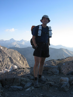
On July 31 at 5:05 a.m., I began my journey on the John Muir Trail at Whitney Portal. The sense of dread and excitement was soon replaced by wonder for the deep granite of Lone Pine Canyon, the high mountain streams, and delicate meadows. I needed my flashlight only briefly in dark stream canyons then began passing even earlier morning Mt. Whitney climbers. Just before Trail Crest Pass, I was surprised to see Chris Scott, Coyote 4-Play race director and VHTRC (Virginia Happy Trails Running Club) friend, with a group of three other runners finishing a 3 day fastpack trip with an early morning fastpack ascent of Mt. Whitney. After brief hellos, I arrived at Trail Crest Pass at 7:58 a.m. and Mt. Whitney after 11 miles at 8:44 a.m.

When I decided to run the John Muir Trail, it was with mixed emotions. On one hand, it seemed sacrilegious to rush through such a beautiful area. John Muir used the word “saunter” to describe his travels through the Sierra Nevada Mountains and spent hours developing an appreciation for its glacial carved canyons, flowered meadows, and rugged peaks. I would certainly not be sauntering and felt a sense of sadness for what I would be missing. On the other hand I’m an ultrarunner, the John Muir Trail is a premier rugged mountain trail and has an established speed record. It helped that I knew it well enough to plan support. The trail is very difficult for crew to access, requiring overnight backpack trips of 14-20 miles except in two locations in the last 57 miles where it crosses roads.

I left Mt. Whitney at 8:47a.m. after signing the register and catching my breath. With my 2 bottle running pack laden with the day’s food and drink mixes (as well as a small cigarette lighter to start a fire and a garbage bag for an emergency tent), I was able to make decent time. I walked the uphill and rocky downhill, ran the easier downhill and level ground. Maintaining a conservative pace early would be important in preserving myself for the later days. I had an eating schedule that included one tortilla or pita sandwich every 2 hours, and a Clif bar, jelly beans or corn nuts every 30 minutes. I kept to this schedule throughout the trip even as the food I was eating progressively lost its appeal. In retrospect, I wish I had chosen even more variety. Things I loved to eat early in the trip, were so repulsive by the end that they were left for Marmots. I had decided against the weight and time water filtration would require. My father and I hadn’t treated water in the 70’s and 80’s and had never gotten ill. We had been choosy about water sources and I counted on my experience to avoid illness. Giardia usually takes a week to strike, so even if I became ill, it wouldn’t affect my trip. Had I decided to purify my water I probably would have taken Iodine tablets and neutralized the Iodine after 30 minutes with Vitamin C powder. (The commercially available neutralizing pill is ascorbic acid which is the same as Vitamin C—the powder is widely available and works faster since it doesn’t have to dissolve.) Aqua-Mira is probably better for common mountain bugs, but has to sit for 5 minutes to activate. I considered taking a Steri-Pen but it hadn’t arrived. My impression, now that I’ve used it, is that it works well for one person, but is slower than a pump or gravity filter for larger volumes of water.

Crossing Wallace (11:47 a.m.) and Tyndall Creeks (12:59 p.m.) allowed me to soak my shirt and head to keep cool in the hotter afternoon temperatures. I was careful to clean my socks, shoes, and feet every few hours. There were already hot spots on my feet, and I knew that blisters could quickly end the trip. The multiple five minute foot care stops took valuable time, but without them, even more time could have been lost. I had chosen Montrail Hurricane Ridge shoes (Gore-Tex XCR) to try to keep dirt out of my shoes and prevent blisters. It kept the dirt out but blistering still occurred. I’m still not sure whether more breathability and dirt would have been as good.

The second major ascent of the trail, Forester Pass (13,200’), was much more difficult than I expected. Around 2 p.m. I became sleepy and lay down for a 10 minute nap beside the trail. I took several of these naps during my four days on the trail and usually found them refreshing. On the final 1000 feet of Forester Pass my pack felt more like the 70 pound packs I carried for week long trips in my youth. The trail surface and running was much better after leaving the pass at (3:00 p.m.). I met Jeff at Viedette Meadows hiking up the trail to meet me. He radioed ahead to Heather to start dinner. I spent 30 minutes with Heather and Jeff at the Charlotte Lake junction. In my 30 minutes with them, I ate, repacked into my overnight pack, and taped early blisters. Three days after I finished my 93 hour trip, Heather and Jeff started their seventeen day through hike on the John Muir Trail with their one year old daughter Sierra. These things run in the family. I left them, partially restored, at 6:10 p.m.

The overnight pack I carried for the next 70 miles had a base weight of just under 8# and with 1 ½ days of food and water, it weighed about 13#. I had settled on a modified version of the GoLite Speed. I had replaced the helmet holder with lightweight compression straps to save weight and allow better adjustment for smaller loads. The Speed isn’t the lightest pack available, but for running it has a usable hip belt and load lifters. This really helped keep the pack from bouncing when running. I could have traveled faster with running gear but this would mean not sleeping again till I met my father.

Heather accompanied me to the top of Glen Pass (7:03 p.m.), snapped a few pictures, and sent me alone into Rae Lakes and the canyons beyond where I would spend my first night. I got water from a trailside spring and enjoyed the last rays of sun on the Painted Lady (a beautiful formation guarding the Rae Lakes basin). I got my headlamp out at 8:40 p.m. and arrived at South Fork at 9:45 p.m. after 56 miles. I would have liked to go farther since it was another 59 miles from there to my father and they would be harder miles carrying a heavier pack. South Fork had the advantages of low elevation and a bear box (metal box to keep food protected from bears). I was also in need of some foot care after descending the rocky trail. Although a handheld light casts better light and shadows while hiking, a headlamp is far superior for working around camp. I typically hold a Petzl Tikka in my hand while hiking and wrap the strap around my wrist. I quickly set up camp next to Redbeard (a PCT through-hiker), ate the zip-locked remains of my dinner, patched my feet, and went to bed.

One of the final adjustments to my lightweight kit was replacing my much beloved Western Mountaineering Ultralight sleeping bag with a custom 13 oz. Nunatak bag. I had worked with Tom Halpin of Nunatak to make a narrow and fully enclosed 1/3 length foot box and a slightly smaller dimension upper bag. Nearly a pound of weight was saved with this change. This bag and a home-made Epic/Sil-Nylon bivy sack has given me plenty of warmth down to 25 degrees F. I left my Integral Designs poncho/tent, its Fibraplex poles, and titanium stakes with Heather and Jeff. The weather forecasts suggested I wouldn’t need them.

I awoke at 3:50 a.m. without an alarm. Almost immediately a meteor shot in the direction I was heading. I took this as a sign, packed, and started hiking. I was still a bit tired, but still felt excited about the trip though a bit worried about how far I could get that day. I convinced myself that another day of acclimation, lower passes, and less overall elevation gain I could reach my father. Blister repair was required in the dark 15 minutes down the trail. Later, as the moon set and the sun rose, I stopped for a quick breakfast before arriving at Pinchot Pass at 7:28 a.m. With only10 miles between Pinchot Pass and Mather Pass I was hoping for a 3 hour crossing. Additional blister repair and mounting fatigue lost me nearly one hour. I left Mather Pass after a 10 minute nap on a shaded rock ledge at 11:18am. I then ran quickly downhill on mostly good trail to the beautiful alpine Palisade Lakes (12:13 p.m.) then into the manzanita and willow lowland at the base of Muir Pass which was 11 miles and 4000 feet away. Time and distance dragged and I left the top at 6:53 p.m. With 19 miles between me and my father at Blaney Meadows, the chances looked poor for a full dinner, companionship, and an “easy” 50 mile third day. I decided I’d try to reach him only if I continued to hold a good pace. Otherwise, I felt I should at least ford Evolution Creek, so I could start the day with dry and repaired feet. When my pace slowed, I camped 8 miles short of my father after 52 miles and fording Evolution Creek. Because there was no way to let him know I when I would arrive, it was fortunate we had agreed that he would wait for me until noon the next day. After a dinner of instant mashed potatoes (cooked with ½ of an Esbit fuel tab on a Vargo Ti stove in a MSR Ti teakettle), I fell asleep wondering, given my blisters and aching legs, what the morning would bring.

I woke at 5 a.m. and spent nearly 30 minutes dressing blisters and getting packed. It hurt so much getting my shoes on that I expected my trip would be over when I met my father 8 miles later. I resolved to walk for 30 minutes before trying any running. Five minutes down the trail, my shoes and feet had stopped arguing, my legs warmed to an unnoticeable ache and thoughts of meeting my father and a good breakfast had me running the switchbacks down to Goddard Creek. I arrived at the Blaney Meadows Junction at 7:20 a.m., met my father, and plowed into a good meal.

I left Blaney Meadows at 8:02 a.m. feeling great! The good feelings were fueled by a can of river cooled Coke, a breakfast of chicken noodle soup and salmon pasta, and the tender card my wife had hidden in the pack brought in by my father. The euphoria lasted as I carried my smaller Platypus pack up Selden Pass and imagined meeting Mac and Sara at Red’s Meadow, having a shower, and sleeping in a real bed. The good feelings faded in the heat over Bear Ridge, but the good running down to Mono Creek (2:34 p.m.) kept me close to my ideal schedule despite increasing trail dust which necessitated more frequent foot care.

As I started up Silver Pass I began to get sleepy so another 10 minute nap was ordered and delivered on shaded granite. The nap didn’t fully refresh, so I took a caffeine pill in preparation for what now looked like a late arrival at Red’s Meadow. The good feelings were now a distant memory. I reached Silver Pass at 5:07 p.m. and ran into Cascade Valley. At Tully Hole I stopped and spoke with three women backpackers, hoping for some leftover hot dinner. They couldn’t offer this, but it was nice to talk for a few minutes. Although I passed people regularly, I rarely gave more than a friendly greeting. There simply wasn’t time to exchange stories and plans with incredulous hikers. As evening came and I arrived at Virginia Lake I thought of how nice it would be to set up a tent and enjoy the sunset, the alpenglow, then gaze at the stars and moon in their spectacular but subtle light show on the Silver Divide. I really wished I could slow down and enjoy the country I was rushing through.

The trail to Red’s Meadow was filled with numerous small climbs and descents. Sand and cinders repeatedly filled my shoes and a certain desperation developed as twilight slipped into darkness. It was on this section I discovered that every syllable of the “ABC” song can be replaced with the “F” word and I must with shame report that I sung this song repeatedly as I descended into Red’s Meadow. The singing finally stopped at 11:58 p.m. when I arrived at the cabin.

Mac and Sara provided a very welcome respite. The hot shower was heavenly and the pasta filling, but the company and chance to decompress was most appreciated. From Heather and Jeff, to my father, and now Mac and Sara it was friends and family that had made a trip this fast possible. Mac and Sara had even taken off two work days to support my trip. My wife, who could not leave our three children and directly support me, served as the “Where’s Kevin” information station. After a crew met me and got back to a phone, they would call her so she could inform others how I was doing. It helped to know that Mac would be with me all the way to Yosemite Valley. It took a while to fall asleep, but the soft bed was somewhat more comfortable than the thin insulite of the prior two nights.

After a tentative sleep, I woke at 6:15 a.m., dressed, and ate a quick breakfast. Mac and I packed the pre-made sandwiches (Thanks Sara!) and headed off through the valley cold on the final day. The excitement of being only 57 miles from Happy Isles held back the growing fatigue—a little. I took a quick nap by Garnet Lake but it didn’t refresh me so I took a caffeine pill. We arrived at Island Lake Pass at 12:01 p.m., Donohue at 1:52 p.m. and carefully descended the steep, rocky trail to the flats of Lyell Fork canyon. Although I hoped to run this easy section well, the 85F temperatures, tired legs, and a 10 minute foot repair at Ireland Creek ate into the pace. We arrived at Tuolumne Meadows at 6:00 p.m. and had a dinner of chicken noodle soup (delicious after the increasing impalatability of bars and pita sandwiches), sushi (Thanks Sara!!), and nearly 2 L of Dr. Pepper.

By 6:38 p.m. we were ready to go--nearly. With another long night facing me, feet hurting and 22 miles to go, I became scared and thought about quitting. What if I was reduced to a painful limp and couldn’t stay warm? What if I got lost and wandered around in the dark? What if I really got hurt? With the help of Mac and Sara, I screwed up my courage and headed toward the valley with hand bottles of Dr. Pepper and Chunky Man soup.

The evening light on Cathedral Peak again found me pining for a campsite. I repaired my feet for the last time at the Cathedral Lakes junction (8:10 p.m.). It got dark just before Cathedral Pass and we took an unplanned tour through Sunrise camp (9:48 p.m.) before re-finding the John Muir Trail. The five miles to the Merced Lake trail junction looked easy on paper with its 800’ net loss, but this didn’t account for the 1000’ climb that came first or the rocky 1800’ descent that followed. When we finally arrived at the junction, I got a boost from a peanut butter and jelly sandwich. Mac and I then made good time to the Half Dome cut off. I lost the skin and toenail of my right small toe just before Little Yosemite Valley, but figured I couldn’t do much about the pain and just kept going. Below Nevada Falls we descended past several early morning Half Dome climbers. At 2:01 a.m. with 1 mile to go I ran my fastest mile of the trip to try and beat Peter’s record by a full hour. We arrived at the official John Muir Trail start at 2:10 a.m., 93:05 after leaving Whitney Portal.

It’s been several weeks since I finished the John Muir Trail. The mouth sores and blisters have healed. The cold and sore throat that lingered for a week is gone. I’m running again. Am I glad I did it? Yes. Would I do it again? I don’t think so. I’m sure my time will fall someday, but no one can take the experience of four days of living so close to my limits. There will always be those who push themselves to greater levels of misery for greater measures of glory. My next trip to the Sierras will take a bit more time. I will stop to enjoy the stillness and faded colors of twilight, the dappled patterns of shadow edging a warm flowered meadow, and the penetrating crispness of morning air. Life is a process not a destination and there are some beautiful destinations I’d like a bit more time to experience.

Addendum:

Time heals all ills and I’ve been able to think about how I could prepare better for another try. I think the most important factor would be a sustained period of training at elevation. With this I probably could run more of the trail and gain significant time. Some advantage could be gained by lightening my load. I picked up too much food from my first re-supply (and left half of my Pita sandwiches with Redbeard at my first night’s camp). On a future trip I would take a little less food but chose more variety. I would carry less water as I nearly always had a full bottle. Depending on the weather, I might leave my down vest at home (it did make a nice pillow but didn’t get used otherwise). I could probably find a lighter pack comfortable enough for running. I’m not sure I’ll ever do it again, but if I do, I’ll be better prepared. The Tahoe Rim Trail might be an interesting challenge………